



 Katie
Goliboski
Katie
Goliboski
The Relationship Between Humidity, Temperature, and Rainfall… And Can We Do Anything About It?
For us to understand this discussion, let’s review a few scientific terms:
- Humidity: the amount of water vapour (or moisture) in the air. It is the most variable characteristic of the atmosphere and constitutes a major factor in climate and weather.
- Temperature Inversion: a reversal of the normal behaviour of temperature in the troposphere (the region of the atmosphere nearest Earth’s surface), in which a layer of cool air at the surface is overlain by a layer of warmer air. (Under normal conditions air temperature usually decreases with height.)
- Inversions play an important role in determining cloud forms, precipitation, and visibility. An inversion acts as a cap on the upward movement of air from the layers below. As a result, convection produced by the heating of air from below is limited to levels below the inversion. In regions where a pronounced low-level inversion is present, convective clouds cannot rise high enough to enlarge and produce showers. Conjunctively, visibility may be greatly reduced below the inversion, even in the absence of clouds, by the accumulation of dust and smoke particles. Because air near the base of an inversion tends to be cool, fog frequently forms.
- Inversions also affect diurnal variations in air temperature. The principal heating of air during the day is produced by its contact with a land surface that has been heated by the Sun’s radiation. Heat from the ground is communicated to the air by conduction and convection. Since an inversion will usually control the upper level to which heat is carried by convection, only a shallow layer of air will be heated if the inversion is low and large, and the rise in temperature will be great.
- Precipitation: all liquid and solid water particles that fall from clouds and reach the ground. These particles include all types of rainfall, snow, snow pellets, ice crystals, and hail.
- Dew Point: the temperature at which air/the atmosphere has become fully saturated
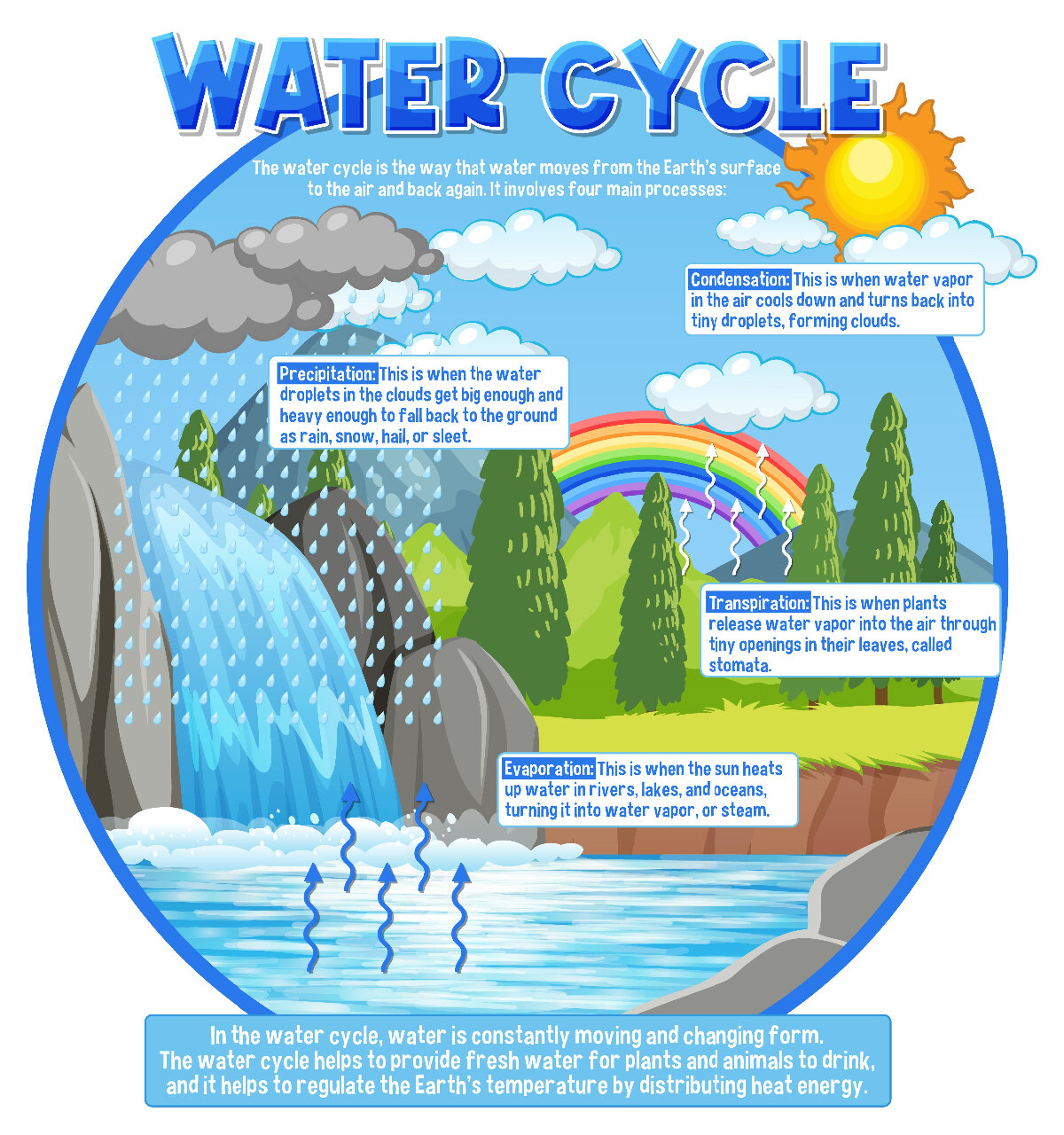
We are all aware that these components affect each other and are part of a hydrological (moisture) cycle that aids in the composition of the Earth’s atmosphere. A key fact is that our atmosphere can retain moisture, and it is this phenomenon that leads to rainfall as the accumulated water vapour molecules are released as rain (or a similar precipitation dependent on environmental conditions) once the capacity of the atmosphere is reached.
Water molecules are pulled into the atmosphere through evaporation from surface water (including soil/land and bodies of water) and transpiration (release of water from leaves of plants) as a result of heat absorption during warm periods, converting them into a gaseous form (vapour) as they absorb heat. The higher the temperature or atmospheric pressure, the more water vapour the air can hold. When a volume of air is holding all the water vapour it can hold, it is said to be “saturated.” It is important to note that warm air can hold significantly more moisture than cool/cold air.
Once the saturation point is reached, the vapour can then release energy and cools, condensing into water droplets that form on small particles in the air such as dust, volcanic ash, pollen, bacteria or sea salt spray. When a number of these droplets collect together, a cloud is formed. The conditions necessary for this reaction to occur are the consequence of either cooling air or the mixing of air masses of different temperatures. Through condensation water vapour in the atmosphere is released to form precipitation.
Water Cycle image designed by Magnific
How do we see water molecules?
The format of the precipitation depends on the temperature in the atmosphere and the conditions of the area where the dew point is reached. This is why there is variation in precipitation formats from rain to snow to hail, etc. varying across the world. Considerations such as altitude, urbanization, vegetation and the location within the continent (ex. coastal versus inland) also play key roles. The type of cloud that has formed to release the molecules can also dictate the precipitation format.
Clouds form as a result of the moisture heavy air rising. The change in pressure to lower pressure at the higher altitudes allows the air mass to expand, cooling without heat exchange (as the elements have less pressure holding them together) and thereby spread the size of their molecules. This occurs until the resulting temperature change falls below the dew point. Then the air becomes supersaturated such that water vapour condenses onto cloud condensation nuclei, or tiny water droplets. These water droplets must reach sufficient size (mass) to overcome the lifting effect of the air currents before they can fall as precipitation.
There are ten types of clouds, broken into three sub-categories based on altitude:
- High-Level Clouds
- Cirrus (Ci), cirrocumulus (Cc), and cirrostratus (Cs) are high level clouds. They are typically thin and white in appearance, but can appear in a magnificent array of colors when the sun is low on the horizon.
- Cirrus (Ci)
- Detached clouds formed of purely of ice crystals. They are in the form of white, delicate filaments, mostly in patches or narrow bands. They may have a fibrous (hair-like) and/or silky sheen appearance.
- Cirrocumulus (Cc)
- Thin and white, these clouds look like a patchy sheet or layer arranged somewhat-regularly into grains or ripples without shading. They are predominantly made of ice crystals, and often form in connection with cirrus or cirrostratus or from a degraded state of these cloud types and are short-lived.
- Cirrostratus (Cs)
- Transparent, whitish veil-like clouds with a fibrous (hair-like) or smooth appearance. A sheet of cirrostratus is very extensive and can cover the whole sky.
- Cirrus (Ci)
- Cirrus (Ci), cirrocumulus (Cc), and cirrostratus (Cs) are high level clouds. They are typically thin and white in appearance, but can appear in a magnificent array of colors when the sun is low on the horizon.
- Mid-Level Clouds
- Altocumulus (Ac), altostratus (As), and nimbostratus (Ns) are mid-level clouds composed primarily of water droplets. However, they can be composed of ice crystals when temperatures are low enough.
- Altocumulus (Ac)
- White and/or gray patchy, sheet, or layered clouds generally composed of laminae (plates), rounded masses, or rolls. They may be partly fibrous or diffuse and may or may not be merged.
- As the most common mid-level cloud, multiple layers of altocumulus often appear at different levels at the same time. Many times, altocumulus will appear with other cloud types.
- Altostratus (As)
- Gray or bluish cloud sheets or layers of striated or fibrous clouds that totally or partially cover the sky. They are thin enough to regularly reveal the sun as if seen through ground glass.
- Sometimes virga (streaks of rain) are seen hanging from altostratus and at times may even reach the ground, causing very light precipitation.
- Nimbostratus (Ns)
- Resulting from thickening altostratus, this is a dark gray cloud layer diffused by falling rain or snow. It is thick enough throughout to blot out the sun. Low, ragged clouds frequently occur beneath this cloud and sometimes merge with its base.
- The cloud base lowers as precipitation continues. Because of the lowering base, it is often erroneously called a low-level cloud. Both altostratus and nimbostratus can extend into the high level of clouds.
- Altocumulus (Ac)
- Altocumulus (Ac), altostratus (As), and nimbostratus (Ns) are mid-level clouds composed primarily of water droplets. However, they can be composed of ice crystals when temperatures are low enough.
- Low-Level Clouds
- Cumulus (Cu), stratocumulus (Sc), stratus (St), and cumulonimbus (Cb) are low clouds composed of water droplets. Cumulonimbus, with its strong vertical updraft, extends well into the high level of clouds.
- Cumulus (Cu)
- Detached, generally dense clouds and with sharp outlines that develop vertically in the form of rising mounds, domes, or towers with bulging upper parts often resembling a cauliflower.
- Cumulonimbus (Cb)
- This is the type of cloud responsible for formation of thunderstorms. They are a heavy and dense cloud in the form of a mountain or huge tower. The upper portion is usually smoothed, fibrous, or striated and nearly always flattened in the shape of an anvil or vast plume.
- Under the base of this cloud, which is often very dark, there are commonly low ragged clouds that may or may not merge with the base. They produce precipitation, which sometimes is in the form of virga.
- Cumulonimbus clouds also produce hail and tornadoes.
- Stratocumulus (Sc)
- Gray or whitish patchy, sheet, or layered clouds that almost always have dark tessellations (honeycomb appearance), rounded masses, or rolls. Except for virga, they are non-fibrous and may or may not be merged.
- Stratus (St)
- A generally gray cloud layer with a uniform base which may, if thick enough, produce drizzle, ice prisms, or snow grains. When the sun is visible through this cloud, its outline is clearly discernible.
- Often, when a layer of stratus breaks up and dissipates, blue sky is seen.
- Cumulus (Cu)
- Cumulus (Cu), stratocumulus (Sc), stratus (St), and cumulonimbus (Cb) are low clouds composed of water droplets. Cumulonimbus, with its strong vertical updraft, extends well into the high level of clouds.
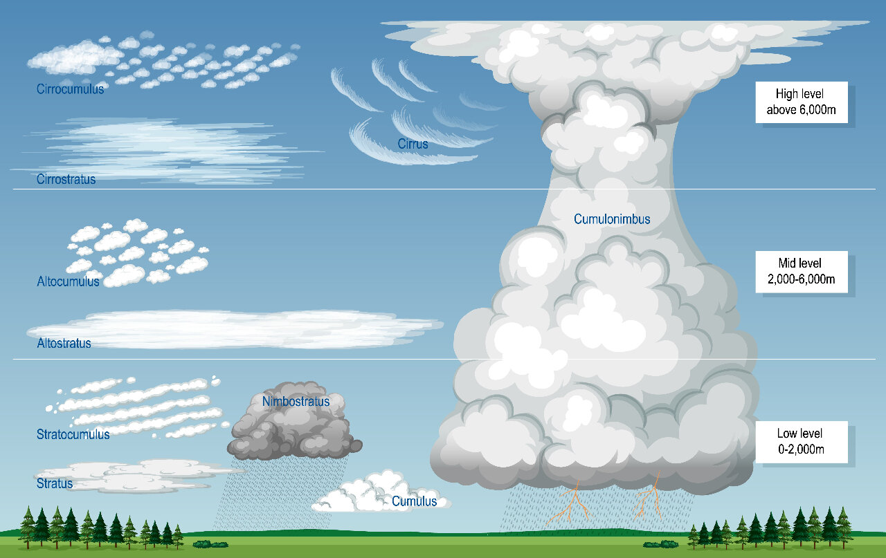
Cloud types image designed by Magnific
How do we get rain then?
The (arguabley) most exciting format we see the water molecules fall in, is a thunderstorm.
Further to the requirement of a cumulonimbus clouds, a thunderstorm requires instability and lift to generate. Instability is generated by warm air rising through cooler air (a temperature inversion), creating a difference in temperature that encourages vertical movement of air particles. This updraft enables the storm to increase in size, and the cycle of air rising and cooling is what feeds the severity of the storm. Lift is a result of environmental factors such as cold fronts and air flow over terrain features (ex. mountains). The moist air must rise in large, swift updrafts to the cooler regions of the atmosphere. There the moisture contained in the updraft condenses to form towering cumulonimbus clouds and, eventually, precipitation.
How do we predict these events?
Meteorologists use all of these aforementioned factors to predict oncoming weather, interpret radar findings, and suggest expected temperatures; however, it is to be noted that increasingly often this interpretation does not play out as expected. We often joke that a weather reporter is one of few jobs where you can be wrong 90% of the time yet still remain employed. Why?
The interactions of cloud cover, humidity and the residual surface temperature resulting from increased urbanization have changed drastically over the past decade. Deteriorating air quality, uncharacteristic heatwaves, and moisture aailability changes are all resulting in alterations to the human perceived levels of heat and humidity. Changes to topography and air flow have also occurred over time and impact weather modeling.
So where does this leave us for how rain relates to humidity??
Moisture for rain is in part a result of the humidity (moisture in the air resulting from evaporation/transpiration). So, as humidity increases the potential for rain increases as well, but there is still a threshold of the atmospheric moisture capacity that must be reached before precipitation can result. It is pivotal to be aware that against our natural instincts, we know that humid air is lighter than dry air. This seems contrary to how it feels, but because water vapour molecules (hydrogen and oxygen) replace the heavier nitrogen and oxygen molecules in the atmosphere, the actual anatomical weight of humid air is less than dry air. Both humid and dry air can co-exist, and it is the interplay between dry and humid air that causes big storms. When dry, dense air moves under moist, light air, it lifts the moist air and makes the right conditions for thunderstorms. High relative humidity is an indication that the atmosphere is close to saturation, but small changes in temperature can impact whether condensation forms or not.
Rain also leads to a higher humidity when temperatures have risen, as the rain evaporates quickly, essentially rejuvenating the available moisture content of the air. This can lead to heavier, longer rainfall periods and more intense weather events. Rain may also cool the air temperature and reduce the rate of evaporation and humidity; as discussed, it’s a give and take dependent on a number of factors.
Singing in the rain...
As a result of climate changes (urbanization potentially affecting inversion levels) and an increase in the capacity of the atmosphere for moisture, it is possible that historical data models are not as accurate as they used to be. This may be why when the weather stations call for rain due to humid, cloudy, weather conditions, we do not get a drop; the potential that the saturation threshold was not met, or the higher atmosphere temperatures were insufficient (too cold) are possibilities. The conditions also change quickly, with thresholds we are not longer certain of; it makes it impossible to accurately predict weather events without further (update) research. The only ways we could affect these changes to reduce our impact on the environment and work on conserving water, to ensure that as higher thresholds for atmospheric saturation are developed, the water is available to meet the need and ensure precipitation can form/be released. It’s all about the big picture on this one.
Humankind has altered the settings of the Earth, and we do not have sufficient, reliable, data to re-write the algorithms used to accurately predict weather systems. An additional complication is the ongoing events happening along the Earth's surface that can also impact the water cycle and thereby change the pressures/thresholds that create the weather. We have made the ground upon which weather predictors stand unstable, nothing to do but watch the skies ourselves and take the predictions with a grain of salt.
If you want to try to undo waht has been done, look to the waterways. Reduce your waste of water and revert to the methods of natural resource preservation we were taught in grade school (Reduce, Reuse, Recycle) along with awareness of energy use (both electricity in general adn technology). These little changes to your life can have big results.